HYDROGRAPHIC SURVEYS:

Masirah international offers a wide range of hydrographic surveys inculding bathymetric surveys, side scan surveys, sub bottom profiling surveys, land survey services and Subsea Investigation surveys. At Masirah international we strive to provide our clients with most accurate possible results using the latest equipments and software. The combined experience of the surveying team and marine construction team allows Masirah International to provide the highest quality to our clients giving a meaningful report every time.
At Masirah International, our Engineering and Planning Department offers following subsea investigation services for your project.

Side Scan Survey work requires extreme understanding of sea weather, Vessel Tracking along with Excellent computing skills by the surveyor. Our experts guide us to get the best results by employing the methods devised based on project needs. Masirah International recently completed a Side Scan Survey job in Musandam
At Masirah International, our Engineering and Planning Department offers following subsea investigation services for your project.
Bathymetric Surveys
Masirah International have successfully completed numerous Bathymetric Survey projects recently with our highly advanced bathymetric surveying instruments and produced accurate surveying results confirmed by the various organizations. For instance some of the Bathymetric Surveying projects done by us are.
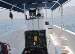
Setup of Equipment on Survey Boat
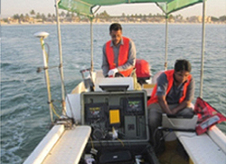
Hyundai's Engr. on Boat for Inspection
Bathymety in Progress at Shattie Salalah
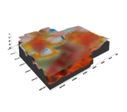
3D View of Seabed Surface
Side Scan Surveys
Masirah International provides Side Scan Survey Services for its clients. This survey is required for big projects and specifically for subsea construction projects. Generally Side Scan Surveys are done for identifications of objects lying on seabed and for condition reporting of sunken vessels.Side Scan Survey work requires extreme understanding of sea weather, Vessel Tracking along with Excellent computing skills by the surveyor. Our experts guide us to get the best results by employing the methods devised based on project needs. Masirah International recently completed a Side Scan Survey job in Musandam
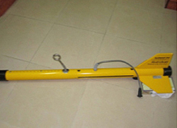
Side Scan Sonar Towfish
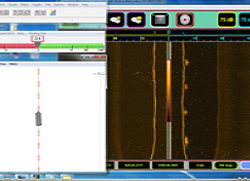
Side Scan Sonar Survey Window
Sub Bottom Profiling Surveys
Sub-bottom profiling systems identify and measure various marine sediment layers that exist below the sediment/water interface. High-resolution sub-bottom systems have been used to detect and measure the thickness of dredged material deposits, detect hard substrate that has been covered by sedimentation, identify buried objects (such as cables and pipelines), and define the basement (or bedrock) layer for potential confined aquatic disposal sites for dredged material. Sub bottom Survey is more than just marine investigations. This requires excellent knowledge of using multiple sonar with vessel tracking parameters in control. We have successfully completed a recent Sub Bottom Profiling Survey job in Musandam.
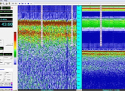
Sub Bottom profiling Survey Window
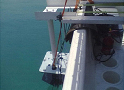
SBP Sonar Installation
Topographical and Land Surveys
Masirah International provides services of Topographical and Land Surveys as well. Our experienced survey team is capable of working onshore and inland. The topographical survey team generally supports our bathymetric survey team and field operations team during construction projects. The survey services onshore and inshore can be provided to clients as well on demand from the client. We have latest equipments like Leica Total Station and Leica Dumpy Level and we are capable of providing data in any required format by the client within accuracy limits.
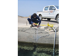
Tide recording and Data Analysis
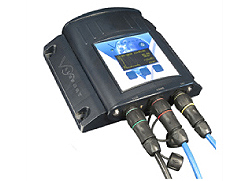
Masirah International Engineering and Planning division is capable of tide recording with our up to date Valeport Tide Master 740 Tide Gauge. The tide gauge data acquisition is done for numerical modeling and for analysis of field data in order to incorporate this data with deisgn calculations. The tide gauge setup is a skilled and specialized job and our special equipments are capable of providing the best data to our clients.
Tide Gauge Setup on Jetty
Valeport Tidemaster 740 Tide Gauge
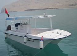
Survey Boat Sabhan in Musandam
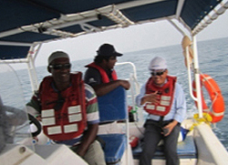
Bathymetric Survey in Progress
COMPLETED HYDROGRAPHIC SURVEYS PROJECTS
| 1 | Topographic and bathymetric survey for twin seawater intake pipeline at Salalah IWPP |
| 2 | Topographic and bathymetric survey for outfall pipeline at Salalah IWPP |
| 3 | Topographic and bathymetric survey for construction of new jetty at Masirah island |
| 4 | Topographic and bathymetric survey for seawater intake and outfall pipeline at Al Khuwaima, Al Sharqiya |
| 5 | Topographic and bathymetric survey for Lima Desalination Plant, Musandam |
| 6 | Topographic and bathymetric survey of Musandam Gas Plant, Musandam |
| 7 | Side Scan and Sub bottom profiling survey for Musandam Gas Plant |
| 8 | Topographic and bathymetric survey for Harmool Beach Erosion Project, Sohar |
| 9 | Bathymetric survey for construction of beach security barriers at Shattie Salalah |
| 10 | Topographic and bathymetric survey for Coastguards Harbor at Sidab, Muscat |
| 10 | Topographic and bathymetric survey for Coastguards Harbor at Sidab, Muscat |
| 11 | Topo survey works for Royal Yachts, Masirah Island, Al Sharqiya |
| 12 | Topographical and MB bathymetric survey at port of Khasab, Musandam |
| 13 | Topographic and bathymetric survey of Seeb outfall pipeline, Seeb, Muscat |
| 14 | Sub bottom profiling survey for Seeb outfall pipeline, Seeb, Muscat |
| 15 | Topographic and bathymetric survey for Sea Rescue Station at Muscat Int. Airport |
| 16 | Topographic and bathymetric survey for Qihayd Desalination Plant, Al Sharqiya |
| 17 | Topographic and bathymetric survey for Lakbi Desalination Plant, Lakbi, Al Wusta |
| 18 | Topographic and bathymetric survey for development of fishery harbor at Mirbat |
| 19 | Topographic and bathymetric survey for development of fishery harbor at Khabura |
| 20 | Topographic and bathymetric survey for development of new fishery harbor at Lima |
| 21 | Sub bottom profiling survey for Qurriyat IWP |
| 22 | Bathymetric surveys for dredging progress monitoring of new fishery harbor at Taqa |
| 23 | Topographic and MB bathymetric survey for Oman LNG at Sur |
| 24 | Side scan survey for Oman LNG at Sur |
| 25 | Topo and bathymetric survey for new fishery harbor at Dhalkut |
| 26 | Topographic and bathymetric survey works for outfall pipelines at Darsait and Azaibah |
| 27 | Topographic and bathymetric survey for land reclamation at MIPP, Musandam |
| 28 | Topographic, geophysical and bathymetric Survey for Qurriyat IWP |
| 29 | Metocean data collection, analysis and reporting for Qurriyat IWP |
| 30 | Metocean data collection for new fishery harbor development at Dhalkut |
| 31 | Topographic and bathymetric survey works for Barka-IV IWP |
| 32 | Geophysical survey works for Barka-IV IWP |
| 33 | Topographic and bathymetric survey of breakwaters’ settlement at Sohar Port |
| 34 | Topographic and bathymetric survey works for Barka-IV IWP |
| 35 | Bathymetric survey works for Darsait and Azaibah outfall pipelines, Muscat |
| 36 | Bathymetric & geophysical survey works for Sharqiya IWP at Al Ashkharah |
| 37 | Annual MB bathymetric survey (S1) for basin and channels at Port of Duqm |
| 38 | Bathymetric & geophysical survey for new Salalah-II IWP |
| 39 | Environmental and water quality survey works for Sharqiya and Salalah IWP’s |
| 40 | Bathymetric survey for Sur Resort, Sur |
| 41 | Topographic and MB Bathymetric survey for breakwater and quay walls at PSQ, Muscat |
| 42 | Bathymetric survey for Muttrah Corniche, Muscat |
| 43 | MB Bathymetric survey works for block 50 offshore area, Duqm |
| 44 | Geophysical survey works for block 50 offshore area, Duqm |
| 45 | Bathymetric survey works for Asseelah Desalination Plant, Al Ashkharah |
| 46 | Bathymetric survey for dredging at Bait al Baraka Harbor at Barka |
| 47 | MB Bathymetric survey works for Sohar Port Southern Development Project, Sohar |
| 48 | Bathymetric survey for Tibet-Khasab Road Project, Musandam |
| 49 | Topographic survey for settlement analysis at damaged quay wall at Port of Duqm |
| 50 | Annual bathymetric survey for maintenance of marina at Muriya Resort, Salalah |
| 51 | Annual bathymetric survey for maintenance of harbor at Jebel Sifah Marina, Sifah |
| 52 | Annual MB bathymetric survey (S2) for basin and channels at Port of Duqm |
| 53 | Bathymetric and topographic and underwater seabed Coring works for Sharqiya IWP |
| 54 | MB bathymetric, geophysical survey works for Salalah SWRO, Salalah, Oman |
| 55 | Bathymetric survey for CACI Tiles at Sur |
| 56 | MB bathymetric survey for Al Ghubra-III IWP |
| 57 | Bathymetric IN survey for Sohar Port Southern Development Project, Sohar |
| 58 | Bathymetric survey works for Oman Rivera Project at Yiti & Yenket, Muscat |
| 59 | MB bathymetric survey works for seawater pipeline at Barka-IV IWP, Barka |
| 60 | MB bathymetric and geophysical survey works for Duqm IPWP, Duqm |
| 61 | MB Bathymetric Survey for Pre and post salvage of Raysut-II at Fazayah Bay, Salalah |
| 62 | Annual MB Bathymetric survey (S3) for basin and channels at Port of Duqm |
| 63 | Water sampling works at Khasab port, Musandam |
| 64 | MB Bathymetric, Geophysical and LiDAR Survey Works for Oman LNG, Sur |
| 65 | MB Bathymetric Survey Works for Quriyyat IWP SWI and OF Pipelines |
| 66 | MB Bathymetric Survey Works for Designing of Offshore Pipelines at Duqm IPWP, Oman |
| 67 | MB Bathymetric Survey for pre and post Khareef Weather Impact on SWI Pipeline, Salalah, Oman |
| 68 | MB Bathymetric Survey for New Jetty Construction at Oman LNG, Sur |
| 69 | MB Bathymetric, Geophysical and Topo Survey for Govt. Berth Project at Port of Duqm |
| 70 | MB Bathymetric Survey Works for Duqm Refinery Seawater Intake Project, Duqm |
| 71 | MB Bathymetric and Geophysical Survey Works at Block 50, Oman |
| 72 | Bathymetric, Side Scan and Tidal Survey for Oceanic Shrimp Aquaculture at Lakbi |
| 73 | Annual MB bathymetric survey (S4) for basin and channels at Port of Duqm |
| 74 | Pre-Marine Survey Works for Ras Markaz Oil Tank Farm, Duqm |
| 75 | SB Bathymetric Survey Works for Bander Beach and Husn Beach at Barr al Jissah Resort |
| 76 | SB Survey for Fish Landing site at Yenket |
| 77 | MB Bathymetric, Geophysical and LiDAR Survey for Oman LNG Outfall Project at Sur |
| 78 | SB Bathymetric, Geophysical, Topographic and Metocean Surveys for Barka-V IWP |
| 79 | SB Bathymetric, Geophysical, Topographic and metocean Surveys for Ghubra-III IWP |
| 80 | MB Bathymetric Survey for Pipeline Conditions Assessment at Quriyyat IWP |
| 81 | SB bathymetric Survey for Wave and Current Direction Analysis for Quriyyat IWP |
| 82 | Debris Assessment Survey for Production Facility at Block 50 Offshore, Oman |
| 83 | Annual MB bathymetric survey (S5) for basin and channels at Port of Duqm, Oman |
| 84 | 3rd Party Arbitration Survey (Between Galfar and Gulf Cobla) for Dredging at Duqm Fishery Harbor |
| 85 | Bathymetric Survey of Al Shorooq Jetty at Sur, Oman |
| 86 | Bathymetric Survey for Beach Rehabilitation Works at Bustan Palace, Muscat, Oman |
| 87 | Bathymetric Survey for Jebel Sifah Marina |
| 88 | SB Bathymetric, Geophysical and LiDar Survey of Barr al Hikman peninsula, Mahout |
| 89 | Oceanographic and Metocean data collection for Barr al Hikman area, Mahout |
| 90 | Water Quality and Environmental Survey for Barr al Hikman area, Oman |
| 91 | Suwadi BM Establishment Survey for Cable Landing site at Suwadi, Al Batinah, Oman |
| 92 | Annual MB bathymetric Survey (S5) for basin and channels at Port of Duqm, Oman |
| 93 | Pre-Dredge bathymetric survey works for Marsa al Safinat at Bait al Barakah, Oman |
| 94 | Levels Measurement Survey at Quriyyat IWP, Oman |
| 95 | Geo Technical Investigation Works at Quriyyat IWP, Oman |
| 96 | Topographic, Bathymetric and Geophysical Surveys Works for Barka-V IWP |
| 97 | Bathymetric survey for Dredging at Musannah Resort, Al Batinah |
| 98 | Topographic and bathymetric survey for Fish Landing Site at Yenket |
| 99 | MB Bathymetric, Geophysical and Topographic Surveys for Barka-V IWP |
| 100 | 42” Buried Oil Pipeline Route Detection at Ras Markaz Oil Tank Farm, Ras Markaz, Duqm |
| 101 | Dredging progress monitoring survey for al Mouj Marina Dredging and Piling Works Project |
| 102 | Hydrodynamic Studies at Duqm Port, Duqm |
| 103 | MB Bathymetric and Side Scan survey for Pipeline Conditions Assessment at Quriyyat IWP |
| 104 | MB Bathymetric and Geophysical survey works for OQ Strategic Fuel Reserve Project at Musandam |
Our previous clients for hydrographic surveys appreciated our work and their satisfaction with our work drove them to involve us in post surveying progress of their projects and we provided consultancy and designing services for all type of marine works for our clients as well. Our aims and objectives are to focus on the satisfaction of the client and to become the first choice of our clients in all type of the marine works starting from a single buoy placement up to the most sophisticated marine jobs.